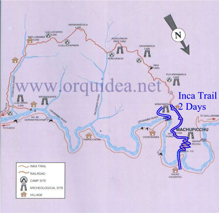
An Inca Trail Map could very helpful; we give you some information about it. The Inca Trail that links the Sacred Valley in Cusco to Machu Picchu is only a part of the extensive network of Inca roads. The best known is 4 or 5 days Inca trail, which begins at km. 82 in Piskacucho, the trek has a distance of 42 km, the second day is considered as the hardest because you have to hike 1,200 meter until Warmiwañusca where you will be at an altitude of 4,200 meters above the sea level. Climate changes during the journey, usually the first two days are sunny and the third and fourth are usually wet and nights are cold.
You will be able to see the changing landscape of the entire trek. In the first two days the landscape is mountainous with forest and streams. On the other hand, the vegetation on the third day becomes more tropical like a jungle. Along the trek you will have the opportunity to see animals such as llamas, hummingbirds, hawks, lizards and sometimes deer. The road runs through part of the Machu Picchu National Park which is the habitat of wild animals such as the puma and the Andean bear, but these are hardly seen.
Here is a brief mention of the places that arew through tha Inca Trail:
Departure of the Inca Trail: Km 82. Altitude: 2682 m. The Inca Trail starts here.
Salapunku: The first Inca archaeological site seen during the Trek. It is located on the right bank of the Urubamba River.
Salapunku or ‘door of the room’, has walls similar to Sacsayhuaman, pre-Inca and Inca architecture, a place that would have been a fort against attacks or possible invasion as well as being the control gate of access to the valley of the Vilcanota
Q’hanamarca: Inca archaeological site.
Ñustajispana: This site is sometimes called Ñustahispana that in Quechua, means the Spanish princess, but her real name means princess urine to remember that even the nobility was made up of human beings
Llaqtapata: Altitude: 2750 m. Llaqtapata which in Quechua means the people on the hillside These ruins, made up for people and Andean terraces are located on the riverbank Cusichaca
Qoriwayrachina: Altitude: 2500 m. Railway station at km 88. It is another starting point for the Inca Trail.
Qoriwayrachina: Altitude: 2500 m. Qoriwayrachina Bridge at km 88, which crosses the Urubamba River
Miskay: Altitude: 2660 m. Lunch at Miskay
Willkarakay: Inca archaeological site
Ruins: Inca archaeological site
Tablachaka: Altitude: 2800 m
Urkapata: Inca archaeological site
First Camp: Altitude: 3390 m. It is Wayllabamba camp
Yuncachimpa: Altitude: 3260 m. Yuncachimpa Camp is sometimes used to spend the first night.
Paucarcancha: Altitude: 3205 m. Inca archaeological site at the confluence of the valleys and Keska Pampacahua.
Coralpunku: Altitude: 3700 m
Llulluchapampa: Altitude: 3800 m
Warmiwañusca: Altitude: 4224 m. It is the highest point of the trail. It is not uncommon for snow here, after passing this area, climate and vegetation correspond to the high jungle of Cusco.
Second Camp: Altitude: 3643 m. Pacamayo camp is located in the valley, where we will spend the second night.
Laguna Saqtaycocha: Altitude: 4260 m. magnificent lagoon that is home to ducks and geese permanently.
Tambo Runkuraqay: Altitude: 3924 m. At km 24, in the valley of Pacaymayo, Tambo Inca is located, a semi-circular ball construction.
Open Runkurakay: Altitude: 3924 m. These are the ruins of which are also open Runkurakay over open.
Laguna Yanacocha: Altitude: 4260 m. Yanacocha in Quechua means the Black Lagoon.
Sayaqmarka: Altitude: 3635 m. At Km 28 is a building shaped maze. Access is by a solid stone staircase on the side of the mountain. Once on top, you can admire the panoramic view over the valley Aobamba and permafrost of the mountain Pumasillo
Paqaymayu: Altitude: 3575 m. Lunch at Paqaymayu
Phuyupatamarka: Altitude: 3580 m. Located at km 32, Phuyupatamarka Village in the clouds means in Quechua. Dominating the Urubamba valley, surrounded by clouds almost permanently.
Wiñawayna: Altitude: 2650 m. Located at km 39, Wiñawayna means forever young in Quechua. It is built into a steep hillside overlooking the Urubamba River.
Last night of camping: Altitude: 2774 m. Winawayana field will welcome the last night of Trek.
Intipata: Altitude: 2850 m. Inca archaeological site.
Choquesuysuy: Altitude: 2145 m. Inca archaeological site.
Chachabamba: Altitude: 2171 m. Inca archaeological site.
Km 104: Altitude: 2151 m. 104 km is the starting point of the trek for 2 days, the short version of the Inca Trail.
Intipunku: Altitude: 2737 m. It Intipunku, or the Gate of the Sun
Machu Picchu: Altitude: 2450 m. Discovered in 1911, is the ma-known Inca citadel in the world. His growing success justified and attracts many visitors throughout the year.
Wayna Picchu: Altitude: 2560 m
Aguas Calientes: Altitude: 2100 m. At the foot of Machu Picchu is the small town of Aguas Calientes.
Railway station: Railway station at the foot of Machu Picchu.
Nevado Salkantay: Altitude: 6271 m. The highest mountain, Cordillera Vilcabamba
Nevado Veronica: Altitude: 5682 m. Located across the valley, the mountain is visible for part of Trek. Its original name is Weqey Willka Tear sacred meaning in Quechua.
