Altitude 3,827 meters (12,500 feet) a.s.l.
Population 91,877 inhabitants in the city
Puno, on the banks of Lake Titicaca – the world highest navigable lake – displays the reminiscences of its origin through cave paintings and spearheads, testimony of our highland ancestor’s life.
The Collao Plateau Is the geographical space, where ancient and Important cultures like Pucara and, later, Tiahuanaco, appeared.This is the region where, according to the legend, Manco Capac and Mama Ocllo emerged from the sacred Lake Titicaca to found the Inca Empire.
During colonial times, the Spaniards established In Puno attracted by its mineral richness, bringing new cultural, social and economic Patterns along. The city of San Carlos de Puno was founded in 1668 and the priests, eager to convert the natives, motivated them to build beautiful churches.
LAKE TITICACA
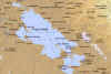
Click on the thumbnail to enlarge map
Lake Titicaca is the world’s highest navigable lake and the center of a region where thousands of subsistence farmers eke out a living fishing in its icy waters, growing potatoes in the rocky land at its edge or herding llama and alpaca at altitudes that leave Europeans and North Americans gasping for air. It is also where traces of the rich Indian past still stubbornly cling, resisting in past centuries the Spanish conquistadors’ aggressive campaign to erase Inca and preInca cultures and, in recent times, the lure of modernization.
When Peruvians talk of turquoise blue Titacaca, they proudly note that it is so large it has waves. This, the most sacred body of water in the Inca empire and now the natural separation between Peru and Bolivia, has a surface area exceeding 8,000 square kilometers (3,100 square miles), not counting its more than 30 islands.
At 3,856 meters (12,725 feet) above sea level it has two climates: chilly and rainy or chilly and dry. In the evenings it becomes quite cold, dropping below freezing from June through August. In the day, the sun is intense and sunburn is common.
According to legend, this lake gave birth to the Inca civilization. Before the Incas, the lake and its islands were holy for the Aymará Indians, whose civilization was centered at the Tiahuanaco, now a complex of ruins on the Bolivian side of Titicaca but once a revered temple site with notably advanced irrigation techniques.
Geologically, Titicaca’s origins are disputed, although it was likely a glacial lake. Maverick scientists claim it had a volcanic start; a century ago, Titicaca was popularly believed to be an immense mountaintop crater. A few diehards today stick to the notion that the lake was part of a massive river system from the Pacific Ocean.
Indian legend says the sun god had his children, Manco Capac and his sisterconsort Mama OcIlo, spring from the frigid waters of the lake to found Cuzco and the beginning of the Inca dynasty. Later, during the Spanish Conquest, the lake allegedly became a secret depository for the empire’s gold. Among the items supposedly buried on the lake’s bottom is Inca Huascar’s gold chain weighing 2,000 kilos (4,400 lbs.) and stored in Koricancha – the Temple of the Sun in Cuzco – until loyal Indians threw it into the lake to prevent it from falling into Spanish hands.
Oceanographer Jacques Yves Cousteau spent eight weeks using mini submarines to explore the depths of the lake but found no gold. (What he did discover, to the amazement of the scientific world, was a 60-centimeter (24-in) long, tri-colored frog that apparently never surfaces!)
Urban base:
On the Peruvian side of the lake is Puno, an unattractive commercial center settled as a Spanish community in 1668 by the Count of Lemos. Although today Puno seems unappealing, during the Spanish period it was one of the continent’s richest cities because of its proximity to the Laykakota silver mines discovered by brothers Gaspar and Jose Salcedo in 1657. The mining boom drew 10,000 people to an area not far from what is now Puno. It also brought a bloody rivalry that ended only when the ironhanded count traveled to Puno, ordered Jose Salcedo executed and transferred Laykakota’s residents to Puno.
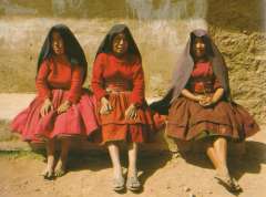
At an altitude of 3,827 meters (12,628 feet), Puno is still the capital Peru’s altiplano – the harsh highland region much better suited to roaming vicuñas and alpacas than to people. It is also Peru’s folklore center with a rich array of handicrafts, costumes, holidays, legends and, most importantly, more than 300 ethnic dances.
Among the latter, the most famous is Devil dance performed during the feast of the Virgin of Candelaria during the first two weeks in February. Dancers fiercely compete to outdo one another in this Diablada, notable for its profusion of costly and grotesque masks. The origins of the dance have become confused over the centuries but it is believed to have started with pre-Inca Indian cultures, surviving through the Inca conquest and the Spanish takeover of the country, with the costumes being modified each time.
Dance and wild costumes:
As numerous as the dances themselves are the lavish and colorful outfits the dancers wear. They range from multi-hued polleras (layered skirts) donned by barefoot female dancers to the short skirts, fringed shawls and bowler hats used in the highland version of the marinera dance. For centuries the Indians in the altiplano were accustomed to working hard, then celebrating their special days with gusto. In fact, many of the dances incorporate features of the most repressive times for the Indians with dancers dressed as mine overseers or cruel landowners characters that are mocked during the festivities. It is difficult to find a month in Puno without at least one elaborate festival, which is always accompanied by music and dance.
Within Puno, there remain a handful of buildings worth seeing. The cathedral is a magnificent stone structure dating back to 1757 with a weather-beaten baroque-style exterior and a surprisingly spartan interior- except for its center altar of carved marble, which is plated in silver.
Over a side-altar to the right side of the church is the icon of The Lord of Agony, commonly known as El Señor de la Bala. Beside the cathedral is the famous Balcony of the Count of Lernos found on an old house on the comers of Deustua and Conde de Lemos streets. It is said that Peru’s Viceroy Don Pedro Antonio Fernandez de Castro Andrade y Portugal – the count -stayed here when he first arrived in the city he later named “San Carlos de Puno.”
On the Plaza de Armas is the library and the municipal pinacoteca, or art gallery and half a block off the plaza is the Museo Carlos Dreyer, a collection of Nazca, Tiahuanaco, Paracas, Chimú and Inca artifacts bequeathed to the city upon the death of their owner, for whom the museum is named.
One of the museum’s most valuable pieces is an Aymará arybalo, the delicate pointed-bottomed pottery whose wide belly curves up to a narrow neck. Throughout the South American continent, the arybalo stands as a symbol 0 the Andean culture.
Views of the Sierra:
Three blocks uphill from the plaza is Huajsapata Park, actually a hill that figures in the lyrics of local songs and an excellent spot for a panoramic view of Puno. Huajsapata is topped by a huge white statue of Manco Capac gazing down at the lake from which he sprang.
Another lookout point is found beside Parque Pino at the city Is north side in the plaza four blocks up Calle Lima from the Plaza de Armas. Also called Parque San Juan, it boasts the Arco Deustua, a monument honoring the patriots killed in the battles of Junin and Ayacucho, the decisive battles in the Independence War with Spain.
The “San Juan” moniker for the park comes from the San Juan Bautista Church within its limits; at its main altar is a statue of the patron saint of Puno, the
Virgin of Candelaria. Also in the park is the Colegio Nacional de San Carlos, a grade school founded by a decree signed by Venezuelan liberation leader Simon Bolivar in 1825. It was later converted into a university, then subsequently used as a military barracks.
Two blocks down F. Arbulu Street from Parque Pino is the city market, a colorful collection of people, goods and food. Tourists should keep their eyes on their money and cameras while here, but it is worth a stop to see the wide collection of products – especially the amazing variety of potatoes, ranging from the hard, freeze-dried papa seca that looks like gravel to the purple potatoes and yellow and orange speckled olluco tubers.
Woolen goods, colorful blankets and ponchos are on sale here, along with miniature reed boats like those that ply Lake Titicaca. Among the more intriguing trinkets are the Ekekos, the ceramic statues of stout jolly men laden with a indefinite number of good luck charms, ranging from fake money to little bags
of coca leaves. Believers say the Ekekos smoke and they are often found with lit cigarettes hanging from their mouths. Those who really believe in the power of these jolly statues claim that they only bring luck if they are received as gifts – not purchased.
Exploring the Lake:
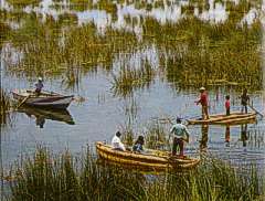
Puno is the stepping-off point for exploring Titicaca with its amazing array of islands, Indian inhabitants and colorful traditions. Small motorboats can be hired for lake trips or for catching the 13kg (30lb) lake trout that make it one of Peru’s best-known fishing destinations.
Most of the transportation is either by motorized launches or the totora reed boats that Norwegian Thor Heyerdahl studied in preparing for his legendary 4,300-nautical mile (7,970-km) journey from Peru to Polynesia in the reed boat Kon-Tiki in the 1940s.
Floating islands:
The best-known of the islands dotting Titicaca’s surface are the Uros, floating islands of reed named after the Indians who inhabited them. Legend has it the Uro Indians had black blood that helped them survive the frigid nights on the water and safeguarded them from drowning.The last full-blooded Uro was a woman who died in 1959. Other Uros had left the group of islands in earlier years owing to a drought that worsened their poverty – and intermarried with Aymará and Quechua-speaking Indians. But the Indians who now inhabit this island – a mix of Uro, Aymara and Inca descendants – follow the Uro ways.

The Uros’ poverty has prompted more and more of them to move to Puno. That same poverty has caused those who remain to take a hard-sell approach to tourists and, besides pressing visitors to buy their handicrafts, they frequently demand “tips” for having their photographs taken.
Some tourists suggest that bartering with fresh fruit is better than money exchanges. However, there is continued criticism that tourism has not only opened the Uros Islands to the stares of insensitive tourists but has destroyed much of the culture as the Indians modified their handicrafts to appeal to outsiders or abandoned traditional practices to dedicate more time to the influx of outsiders.
The Uros islanders fish, hunt birds and live off lake plants, with … 7 — the – important element in their life being elake reeds they use for their houses, boats and even as the base of their five islands – the largest of which are Toranipata, Huaca Huacani and Santa Maria. The bottoms of the reed islands decay in the water and are replaced from the top with new layers, making a spongy surface that is a bit difficult to walk on.
Even the walls of the schools on the bigger islands are made of totora. The soft roots of the reed are eaten, making it a pretty handy thing to have around.
Another island that lures tourists is Taquile, the home of skilled weavers and a spot where travelers can buy wellmade woolen and alpaca goods as well as colorful garments whose patterns and designs bear hidden messages about the wearer’s social standing or marital status. The residents of this island run their own tourism operations in the hope that visits of outsiders will not destroy their delicate culture. There are no hotels on Taquile but the islanders generously open their homes to tourists interested in an overnight stay.
Handicrafts also play an important role in life on Amantani, a lovely and peaceful island even further away from Puno than Taquile. Amantani was once part of the Inca empire, as attested to by local ruins, before the Spanish invaded and slaughtered the islanders. The Spaniard who was granted a concession to the island used the Indians in forced labor and his descendants were still in control after Peru’s independence from Spain. But eventually an island fiesta turned violent and the Indians attacked their landlord with hoes and consequently split up the island into communally-held fields.
Amantani has opened its doors to outsiders who are willing to live for a few days as the Aymará-speaking islanders do -and that means sleeping on beds made of long hard reeds and eating potatoes for every meal. There is no running water or electricity and nighttime temperatures drop to freezing even in the summer. But those happy to rough it catch a glimpse of an Andean agricultural community that has maintained the same traditions for centuries. Some Amantaní residents live and die without ever leaving the island.
Journeys to Amantaní begin at the Puno docks aboard sputtering wooden motorboats operated by the islanders. At the end of the four-hour trip, visitors are registered as guests and assigned to a host family. The family, usually led by a shy patriarch, shows the way to its mud-brick home set around an open courtyard decorated with white pebbles spelling out the family’s name.
Prepared visitors usually bring gifts of fruit -a rarity on the isolated island and the socializing begins when a family member who speaks English offers a guided walk around the island, from where the views are something spectacular. Women wearing traditional black and white lace dresses pass by with Islingshots in their hands to kill scavenging birds.
Another island, Esteves is connected to Puno by a bridge and is best known for Turistas Isla Esteves This luxury hotel is a far cry from what used to be the main construction on the island – a prison that accommodated the patriots captured by the Spanish during Peru’s war for independence.
James Orton, a naturalist and explorer who died crossing Titicaca on a steamship in 1877, is buried on Isla Esteves; his memorial sits beside one honoring the liberation fighters who perished in the war with Spain. Orton, a natural history professor from Vassar University, was on his third expedition to explore the Beni river in the Amazon area. The Beni’s link to the Mamore river both crucial conduits during the jungle’s rubber boom – was named the Orton river in his honor.
Mysterious burial chambers:
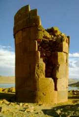
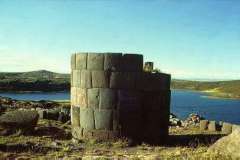
Some 35 km (21 miles) from Puno is Sillustani, with its circular burial towers or chullpas overlooking Lake Umayo. The age of the funeral towers, which are up to 12 meters (40 feet) high, remains a puzzle. A Spanish chronicle-keeper described them as “recently finished” in 1549, although some still appear as if they were never completed and the Indians that built them were conquered by the Incas about a century earlier.
The chullpas apparently were used as burial chambers for nobles of the Colla civilization; these were Indians who spoke Aymara, had architecture considered more complicated than that of the Incas and who buried their nobility with their entire family.
Not far away is Chucuito, a village that sits upon what was once an Inca settlement and which boasts an Inca sundial. Stop by the Santo Domingo Church with its small museum in this altiplano village; also worth visiting is La Asuncion Church.
Juli, once the capital of the lake area, has four beautiful colonial churches under reconstruction. Although it now appears a little odd to see so many large churches so close together, at the time the Spanish ordered them built they hoped to covert huge masses of Indians to Roman Catholicism.
In addition, the Spanish were accustomed to having one church for the Europeans, one for the mixed-raced Christians and yet another for the Indians. The largest of Juli’s churches is San Juan Bautista with its colonial paintings tracing the life of its patron, Saint John the Baptist.
From the courtyard of La Asuncion Church visitors have a captivating view of the lake. The other churches in the city are San Pedro, once the city’s principal place of worship and the church in which a choir of 400 Indians used to sing each Sunday, and Santa Cruz, which is just beside the city’s old cemetery. Santa Cruz was originally a Jesuit church upon the front of which Indian stonemasons carved a huge sun – the Inca god – along with more traditional Christian symbols.
It is from Juli that the Transturin catamarans leave across the lake for Copacabana, Bolivia. (Information is available from the Transturin office in Puno, Av. Girón Tacna 201. Tel: 737).
Pilgrimage site:
Copacabana can also be reached by taking a minibus rid around the side of the lake, passing the reeds waving in the wind, shy but curi ous children at the bends in the road and always the brilliant blue of Titicaca or the roadway that ends the lake.
This pleasant trip involves a short ferry trip at the Strait of Tiquina and the destination is a pleasant one. Copacabana is a friendly little town accus tomed to tourists and has a number o modest but clean restaurants and hotels It is most famous for its cathedral containing a 16th-century carved wood figure of the Virgin of Copacabana, the Christian guardian of the lake.
The statue, finished in 1853, was the work of Indian sculptor Francisco Tito Yupanqui, nephew of Inca Huayna Capac. Except for during Mass, the statue stands with its back to the congregation – but facing the lake so it can keep an eye out for any approaching storms and earthquakes.
One of the loveliest outings in Copacabana is a dawn or dusk walk along the waterfront, watching the sky explode into color with sunrise or slip into the blue black of night at sunset.
It is also possible to reach Bolivia by crossing around the other side of the lake via Desaguadero, but this border town is one of the continent’s filthiest and there is no acceptable lodging there in the event buses on the Bolivian side are not running (a common eventuality owing to holidays, strikes or sometimes lack of demand).
From Copacabana, launches can be hired to visit the Bolivian islands which are also on Lake Titicaca – the Island of the Sun and the Island of the Moon. The Island of the Sun (also accessible via a public ferry) has a sacred Inca rock at one end and the ruins of Pilko Caima with a portal dedicated to the sun god at the other. The Island of the Moon, which is also sometimes called Coati, has ruins of an Inca temple and a cloister for Chosen Women.
