LOCATION
The Machupicchu archeological complex is located in the department of Cusco, in the Urubamba province and district of Machupicchu. It is perched on the eastern slopes of the Vilcanota mountain range, a chain of mountains curtailed by the Apurimac and Urubamba Rivers. At latitude 13º7′ South and longitude 72035′ West of the Greenwich Meridian, Machupicchu is located at a height of 2,350 meters above sea level (main square).
CLIMATE AND ENVIRONMENT
It is located in a subtropical zone, or dense wood, the reason why the climate is mild, warm and damp, with an average year-round temperature of 130C during the day. One can perceive two distinct seasons during the year: the rainy season from November to March, which is a time of heavy rains. Visitors are advised to dress accordingly during this season. The dry season from April to October brings on higher temperatures.
FLORA AND FAUNA
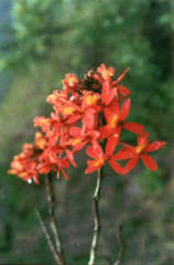
Both are abundant and varied. Typical plant life in the historic reserve of Machupicchu includes pisonayes, q’eofias, alisos, puya palm trees, ferns and more than 90 species of orchids.The fauna in the reserve includes the spectacled bear, cock-of-the-rocks or “tunqui”, tankas, wildcats and an impressive variety of butterflies and insects unique in the region.
The lie of the land, the natural surroundings and the strategic location of Machupicchu lend this monument a fusion of beauty, harmony and balance between the work of the ancient Peruvians and the whims of nature.
HISTORY
One cannot pinpoint the first to populate these lands, as it was a time of occupation rather than foundations. Machupicchu was visited by explorers well before Hiram Bingham, although with little success. These included Antonio Raymondi, the Count of Sartiges and Charles Wiener. Other visits included one in July 1909 by the Santander brothers, whose inscription can be found carved into the base of the Temple of the Sun. At the same time, Peruvian explorers Enrique Palma, Augustin Lizárraga and Gavino Sánchez arrived at the citadel by the route of San Miguel.
The railway line runs parallel to the river in winding loops that follow the riverbed. From here one can seethe typical vegetation of the upper jungle, which climbs up to the top of the steep mountain range that forms the Urubamba Canyon. The train passes through the Chilca train station from where one can see the snowcapped peak called “Veronica”. With a height of 5,750 meters above sea level, it is the highest peak in the Urubamba range. The train stops at Kilometer 88, where the Inca Trail begins.
The train then continues on its way, passing through the station of Pampacahua and the town of Aguas Calientes, located at Kilometer 110. When the train line comes up against a wall of imposing granite mountains, it then plunges into two tunnels before arriving at the station of Puente Ruinas. From here, minibuses take the travelers up 8 kilometers of roads up to the Tourist Hotel. The entry control to the Inca citadel is done near the hotel.
The guided tour of Machupicchu starts on a path that leads from the bus terminal. The path, built on purpose for tourism, enters the citadel in the section that houses a cluster of rooms near the outer wall. The path continues through a terrace to gain access to the agricultural zone before arriving at the urban area.
ARCHITECTURE
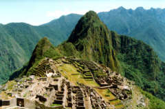
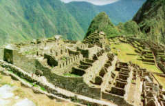
The citadel is divided into two sectors: the agricultural (terracing) and the urban, where there are main squares, temples, palaces, storehouses, workshops, stairways, cables and water fountains which run through both sectors, which measure 20 and 10 hectares respectively.It is clear that the architectural design was based on Cusco, the capital of the Inca empire. Machupicchu was built according to its natural surroundings, with its constructions following the natural curves and dips and rises in the land.
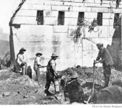
The archeological excavation that took place after Bingham discovered the ruins showed the land was previously given granite foundations with little surrounding soil.
The agricultural and urban sectors are split by a dry ditch, the result of a geographic fault line.
The following chapters describe the most important constructions in each sector.
THE AGRICULTURAL SECTOR
The sector is surrounded by a series of terraces of different types and sizes which had two main functions: to grow crops and halt the erosion caused by the rains. The most eye-catching terraces lie at the entrance to the citadel. They begin at the cluster of rooms located at the entrance and climb up to the top of the mountain until they stop at a large rectangular room.It is clear that the upper terraces at the entrance were meant for agricultural purposes as they have raised steps and are much wider. The lower terraces, meanwhile, have different shapes because they were built as foundations.
There are no canals as they were not necessary, as the constant rains and ever-present humidity allowed the plants to grow without irrigation. The only water channel that flows through the urban sector crosses through the central terrace.
In the agricultural sector there are five rooms that look like Chincheros and Ollantaytambo storerooms.
THE CONTROL GATE
This is made up of a three-walled room with a view with several windows, which can be found in front of the main gateway. There is a go panorama from here of the agricultural and urban sectors and the surrounding landscape. It is a good idea to take photos from this angle as it gives the visitor a good view of the complex.
THE UPPER CEMETERY AND RITUAL STONES
In every Inca city, the dead were buried on the outskirts of the town, which is where in this case Cusco archaeologists found human remains. In the upper part, they also found sculpted stones that belong to the area, which indicated the Incas used the stones to make offerings to their gods. On this same piece of ground lies a granite boulder sculpted with steps. But the most striking feature is that it is pierced with a ring, the purpose of which is unknown. This ritual boulder is very similar to that of the ñusta-hispana in the Vilcabamba I ruins. In the upper part one can see a body-shaped spot as if people had been placed on their backs.
THE URBAN SECTOR
While the agricultural sector is cut short by a dry ditch, one can see a long stairway that leads to the front gate.
This sector houses the most important constructions of any Inca city, where one can appreciate the talent, effort and quality of the pre-Hispanic builders, as the constructions are entirely made of granite, a very hard rock that is different from that used in Cusco.
The city is U-shaped. In the northern section there is the great religious sector containing the temples, to the South there are the houses and workshops on platform terraces that Bingham called the Military Group. The main buildings in the Urban Sector are the following:
THE TEMPLE OF THE SUN
This construction is shaped like a semi-circle and built on solid rock, an existing granite block shaped to blend with the natural curves, with a diameter of 10.50 meters. It is composed of highly polished polyhedrons. There are two trapezoidal windows in this building with protruding knobs at every comer, and on the north side there is a carefully-sculpted door with bored holes in the doorjamb, very similar to the Qoricancha temple in Cusco. The Spanish historians relate there were once gold and precious jewels encrusted in the door. To the West of the temple there is a rectangular patio with nine ceremonial doorways alternating with prism-shaped studs. THE INTIWATANA
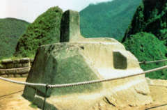
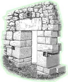
This stone is located on a hill made up of several terraces. The visitor can gain access to the stone via 78 well-crafted steps. At the end of the staircase one enters an open patio with walls equally well-sculpted, and where one can see an upper platform where there is a granite rock sculpted into three steps. In the central part one can see a rectangular prism that is 36cm high and which is pointing from North-West to South-East.
Its four corners are directed to the four cardinal points. The Intiwatana had specific functions: it measured time (the solstice and the equinox) by using sunlight and shadow, and also served as an altar. In Quechua, “Inti” means “sun” and “Wata” means “year”, thereby giving us the meaning of a solar year observatory.
THE GROUP OF THE SACRED ROCK
The sacred rock, located in a four-sided spot flanked by two three-sided rooms, features a monolithic rock sculpture which is 3cm high and 7m wide at its base. The pedestal, which is approximately 30cm high, resembles a feline. From another angle, It looks like the profile of a mountain near Machupicchu. It is possible that this cluster of constructions, together with two “Wayranas”, or three-sided rooms, were used for rituals.
THE TEMPLE OF THREE WINDOWS
It is located West of the main square, has a large rectangular floor. Its name comes from the fact its main face has three windows and two blind bays. Together with the main temple, this is the most impressive architecture in all of Machupicchu. The enormous polyhedrons have been carved and joined with millimetric precision.
In front of the Wayrana-style construction, on the large doorjamb next to the central column that holds up the roof, there is a sculpted lithograph with carefully polished molds and flat parts.
MAIN TEMPLE
The temple is located North of the Sacred Square, very near the Temple of Three Windows. It is built of three walls and is 11m long and 8m wide.
THE DOORS
Doors are a common sight in Machupicchu and especially in this sector. They vary in texture, size and architectural style that set them apart from each other, although all have the same trapezoid shape. Some only have one doorjamb and lintel, and some have two. Some doors are simple and others have different security mechanisms such as stone rings, central trunks and other mechanisms which served to tie together beams to make the doors more secure.
THE FOUNTAINS
To the South of the complex, between the Temple of the Sun and the Royal Palace, the area houses a series of water fountains, the only sources of the vital element for the residents of Machupicchu. The first three water fountains or “PaqchaS7 in Quechua, have been extremely well sculpted. The architectural structures in this area are basically sculpted rock to which are added other decorations such as the spillway and the side walls. This beautiful finish is due to the harmony existing between the Temple of the Sun and the Royal Palace. These fountains were fed by underground water and carried via a canal to be used for irrigation of crops.
THE TOMB
The enormous leaning block of stone that holds up the Temple of the Sun has a large crack in its bottom part, which has been exceptionally skillfully decorated and furnished to be later used as a tomb.
It was also a site of worship and offerings to the mummified bodies of the main authorities. In the doorway it shows a carving portraying the symbol of the goddess Mother Earth. In its interior there are niches, monolithic pillars and other accessories used for religious means and to attend the mummies.
THE SQUARES
There are four main squares at different levels, but share the characteristic of being rectangular in the classic Inca style, interconnected by sunken stairways in the parameters of the terraces. The main square is the largest, which just like the main squares in all Inca cities, had religious and social functions.
The fourth open area is a square flanked by terraces with their respective access ways, similar to the 1,000 B.C. Chavin culture.
On July 14, 1911, Hiram Bingham arrived together with a team of Yale University specialists in topography, biographies, geology, engineering and osteology, led by local inhabitant Melchor Arteaga. They asked him about the city, and he told them it was located on top of an old peak (“Machupicchu” in Quechua).
Later, in 1914 Hiram Bingham returned to Machupicchu with economic and logistic backing from Yale University and the U.S. Geographic Society with the specialists mentioned above, whose report was published and made available around the world with the title “The Lost City of the Incas”.
In the original map, Bingham carved Machupicchu into sectors according to the four cardinal points. Some names have remained the same, but 76 years after the discovery of Machupicchu, scientific studies carried out by archaeologists from the archaeological foundation of the National Cultural Institute as well as delegations of foreign scientists, have provided valuable conclusions about the use and functions of the buildings. These were based on archaeological excavations and the architectonic relations between the buildings with similar construction across the vast Inca empire.
The periods of occupation have been broken down into the following, based on historical accounts, construction style and ceramics:
1. Initial (up to 1,300 A.D.)
2. Classic (up to 1,400 A.D.)
3. Imperial (up to 1533 A.D.)
4. Contact or Transition (1533 to 1572)
DESCRIPTION OF THE ROUTE TO MACHUPICCHU
There are 112krn of railway line between the city of Cusco and the station of Puente Ruinas or Machupicchu. The trip starts in the station of San Pedro in Cusco, zig-zagging up the Picchu mountain until it reaches the highest point, a spot called “El Arco” (the arch), in the northwest part of the city.
– The route then descends to the villages of Poroy, Cachimayo and lzcuchaca until it reaches the Anta plains, an extensive cattle area. It climbs down the gully of Pomatales before descending to the Sacred Valley of the Incas, arriving at the station of Pachar. The route then crosses the Urubamba River to the right bank and arrives at the station of Ollantaytambo. For those who arrived here by the asphalt road of the Sacred Valley, one can board the train to continue to Machupicchu.
HOT SPRINGS:
At a distance of 800m East of the town of Aguas Calientes, there are underground hot sulfur springs which bubble up from the rocky ground at varying temperatures.
The especially-built pools at this resort are the basis of its use as hot mineral baths. The average temperature of the water runs from 38ºc to 46ºc. There are also changing rooms, bathrooms and a small snack bar.
RAIL TRANSPORT
Tourist Train, It only operates in the high season, leaving Cusco in the morning, stopping at the most important stations (Ollantaytambo, Km.88 or Ooriwayrachina) until it arrives at the station of Puente Ruinas. The trip takes four hours and returns in the evening.
Autovagon, This tourist service leaves Cusco in the morning and takes three hours. The trip from The Sacred Valley of the Incas (Urubamba to Ollantaytambo) takes 1,1/2 hours. It returns in the evening.
It is recommended to check all timetables in train stations and travel agencies, as they are modified according to the season.